Introduction to HydroMT#
HydroMT (Hydro Model Tools) is an open-source Python package that facilitates the process of building and analysing spatial geoscientific models with a focus on water system models. It does so by automating the workflow to go from raw data to a complete model instance which is ready to run and to analyse model results once the simulation has finished. As such it is an interface between user, data and hydro models.
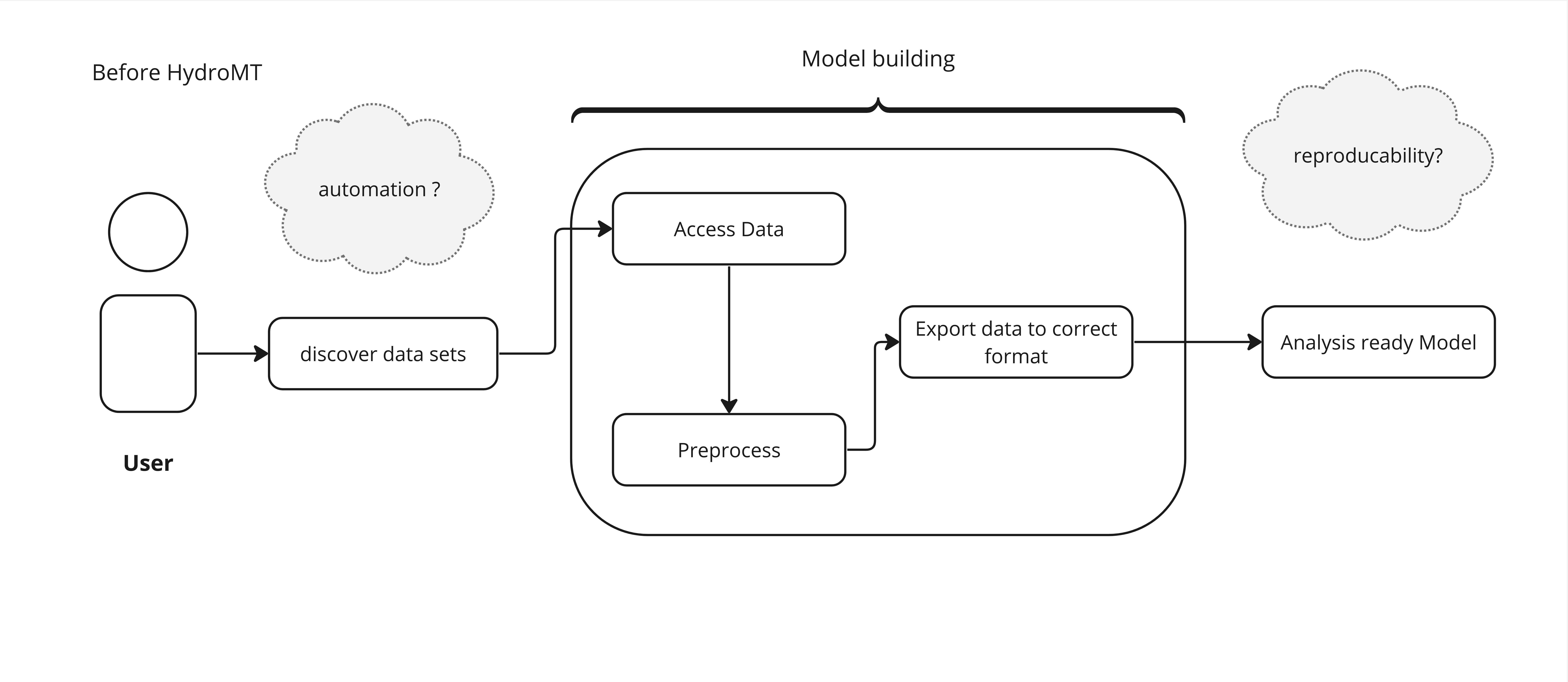
This process, before HydroMT is introduced is pictured below:

A sequence of a typical pre-analysis workflow, before HydroMT was invented#
In contrast to the image above, the same workflow using HydroMT is depicted in the next image:

A sequence describing how the pre-analysis goes using HydroMT#
The main use of HydroMT is to build or update a model instance from raw data. This includes reading and harmonizing the raw input data via the Data Catalog, and transforming the data through a series of methods and workflows to the model specific format and requirements. More concretely HydroMT is organized in the following way:
Input Data
HydroMT is data-agnostic through the
Data Catalog, which allows to read a wide range of data formats and unify the input data (e.g., on-the-fly renaming and unit conversion) via the HydroMTDrivers. Datasets are listed and passed to HydroMT in a user defined data catalog yaml file. HydroMT also provides several pre-defined data catalogs with mostly global datasets that can be used as is, although not all datasets in these catalogs are openly accessible. Currently, five different types of input data are supported by the Adapters and represented by a specific Python data object: gridded datasets such as DEMs or gridded spatially distributed rainfall datasets (represented by RasterDataset objects, a raster-specific type of Xarray Datasets); tables that can be used to, for example, convert land classes to roughness values (represented by Pandas DataFrame objects); vector datasets such as administrative units or river center lines (represented by Geopandas GeoDataFrame objects); time series with associated geo-locations such as observations of discharge (represented by GeoDataset objects, a geo-specific type of Xarray Datasets); non-spatial N-dimension data (represented by Xarray Dataset objects).Models
HydroMT defines any model instance through the model-agnostic
ModelAPI based on several possible components: maps, geometries, forcings, results, states, and the model simulation configuration. For different types of general model classes (i.e., gridded, vector, mesh and network models) additional model components have been defined. Each component is represented with a specific Python data object to provide a common interface to different model software. Model instances can be built from scratch, and existing models can be updated based on a pipeline of methods defined in amodel build workflow.yaml file. While HydroMT provides several general model classes that can readily be used, it can also be tailored to specific model software through a plugin infrastructure. These plugins have the same interface, but with model-specific file readers, writers and workflows.Methods and workflow
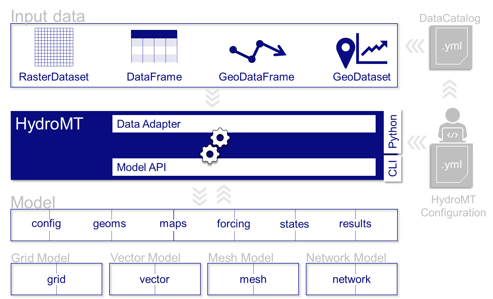
Most of the heavy work in HydroMT is done by Methods and workflows, indicated by the gear wheels in the image A diagram showing an overview of the architecture of HydroMT. below.
Methodsprovide the low-level functionality such as GIS rasterization, reprojection, or zonal statistics.processescombine several methods to transform data to a model layer or post-process model results. Examples of workflows include the delineation of hydrological basins (watersheds), conversion of landuse-landcover data to model parameter maps, and calculation of model skill statistics. Workflows are implemented for the data types mentioned above to allow reusing common workflows between HydroMT plugins for different model software.
Finally user can interact with HydroMT through the following interfaces:
Command Line Interface (CLI)
The CLI is a high-level interface to HydroMT. It is used to run HydroMT commands such as build, update
Python Interface
While most common functionalities can be called through the CLI, the Python interface offers more flexibility for advanced users. It allows you to e.g. interact directly with a model component Model API and apply the many methods and workflows available. Please find all available functions API reference

A diagram showing an overview of the architecture of HydroMT.#
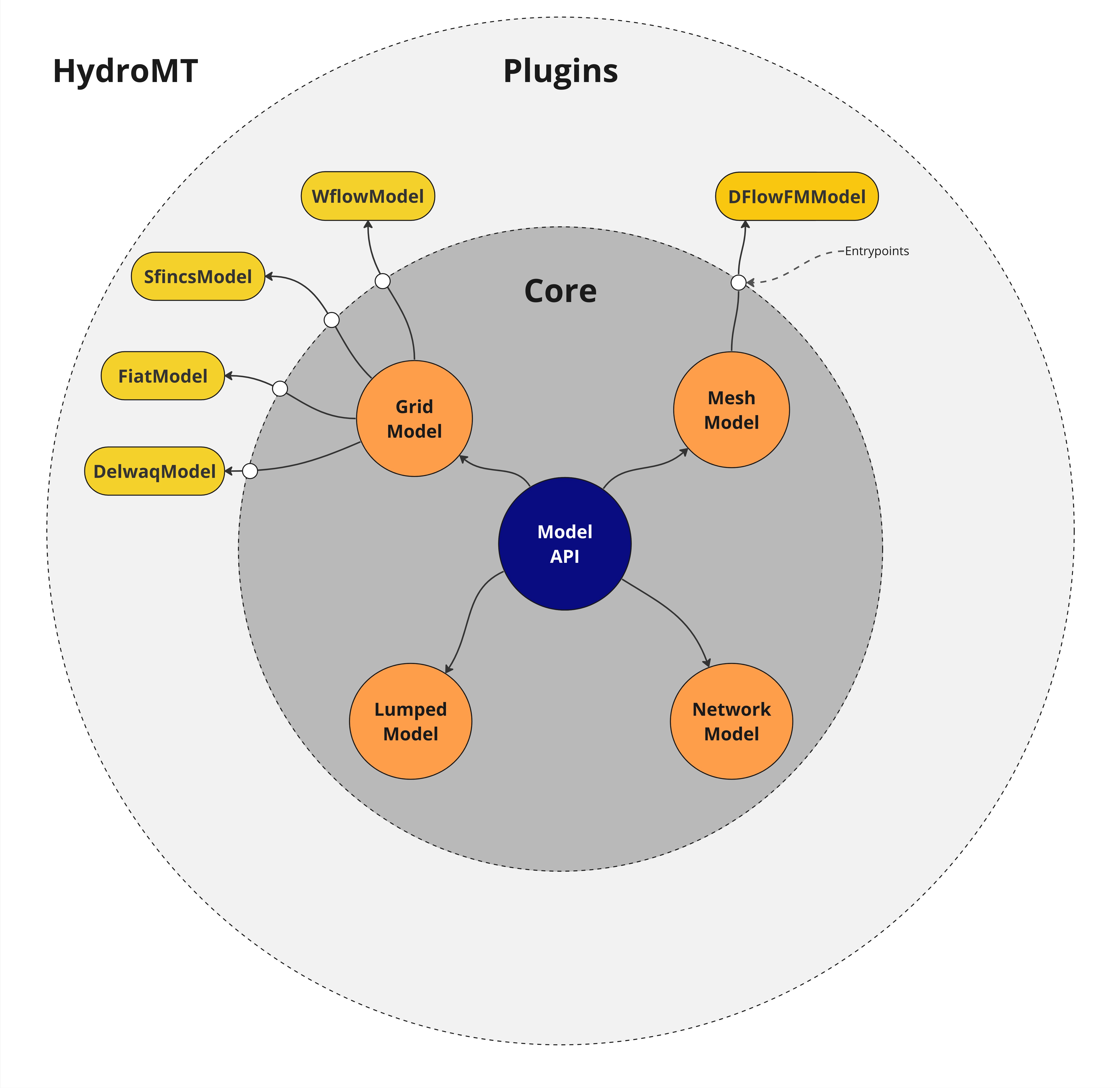
HydroMT is designed to be modular and extensible. Because all models are unique in their own way, for example different model file formats(netcdf, text, binary etc.), it is built around a plugin architecture. This plugin architecture allows to prepare ready-to-run model instances for different model software. For less complex models or for common model file formats. The plugin architecture of HydroMT is depicted in the following image:

A diagram showing an overview of HydroMT and it’s plugin architecture.#
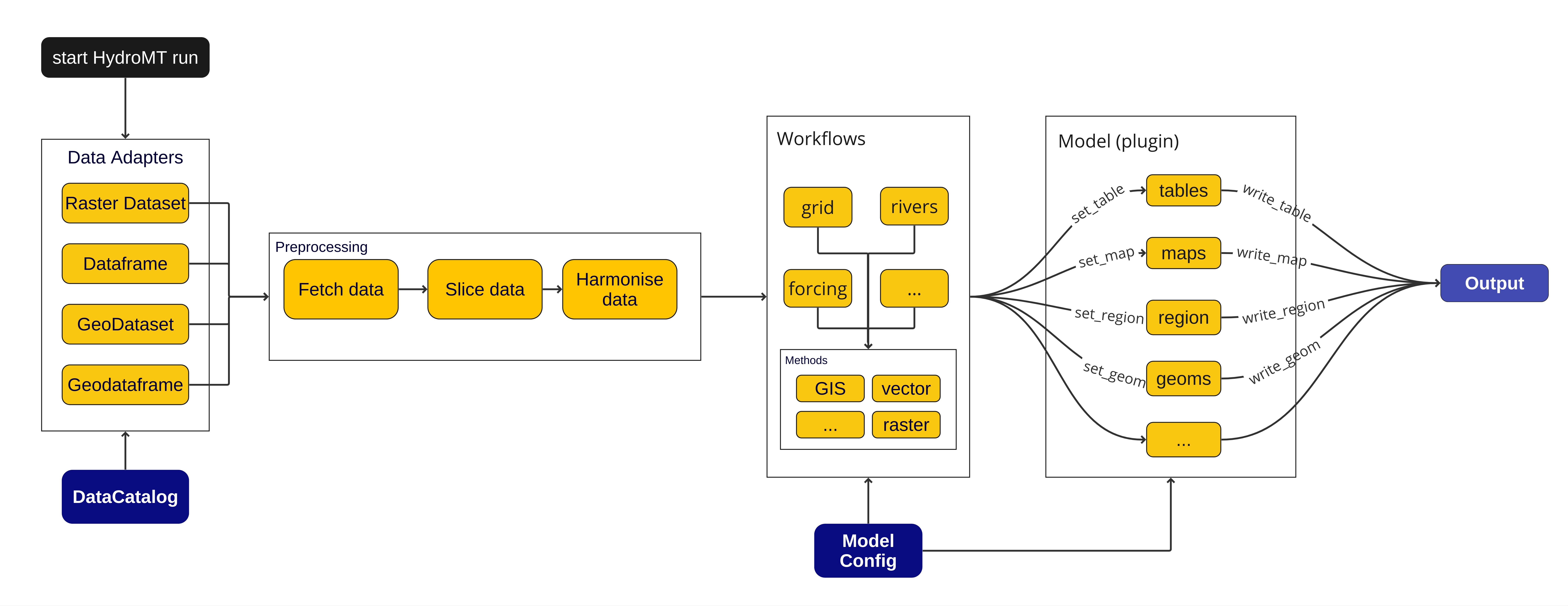
To summarize, the functionality of HydroMT can be broken down into five components, which are around input data, model instances, methods and workflows. Users can interact with HydroMT through a high-level command line interface (CLI) to build model instances from scratch, update existing model instances or analyze model results. Furthermore, a Python interface is available that exposes all functionality for experienced users. A more detailed overview of how HydroMT functions internally is pictured below:

A schematic overview of the sequence of steps that are involved in a HydroMT run.#