


Setup Ponding#
Note
The methods setup_ponding_from_map and setup_ponding_from_threshold
will be added in a future release when wflow.jl supports it. The
documentation for these methods is already included here in anticipation
of that support.
Description#
Many nature-based solutions (NBS) for water management share a common hydrological mechanism: the temporary storage (ponding) of water on the land surface, followed by enhanced infiltration and groundwater recharge. Although such measures differ in form and scale, their effect is to slow overland flow, increase residence time, and promote re-infiltration into the soil.
To better represent these processes, new functionality has been added to the wflow model. First, re-infiltration of overland flow is now allowed, enabling water that would previously be routed laterally downstream to infiltrate back into the soil. Second, a ponding threshold has been implemented: below a specified water depth, overland flow does not move laterally but ponds on the land surface, increasing the potential for infiltration and recharge. When this threshold is exceeded, excess water resumes lateral flow.
This ponding concept provides a flexible, process-based representation of a wide range of NBS measures that involve surface water retention and infiltration, including:
rainwater harvesting
terracing
small ponds in forested hillslope
plastic-lined water harvesting ponds in cropland area
hedgerows / stone lines / springshed revival through trenches and check dams in croplands areas
soil bunds / demi-lunes
As a start, two methods have been implemented to set up ponding level in hydromt wflow:
setup_ponding_from_map: creates pond level based on a user specifiedpond_leveland a pond location map (raster or vector). The ponding level is applied to all grid cells where the ponding map indicates the presence of a pond (all non-nodata values for a raster or all features for a vector).setup_ponding_from_thresholds: creates pond level based on a user specifiedpond_leveland a suitability map derived from landuse and/or hydrography criteria. The topographic criteria are based on the elevation, slope and hand maps, and the landuse criteria are based on the landuse map. For each criterion, a range of suitable values can be defined, and the final ponding suitability is determined by the intersection of all criteria.
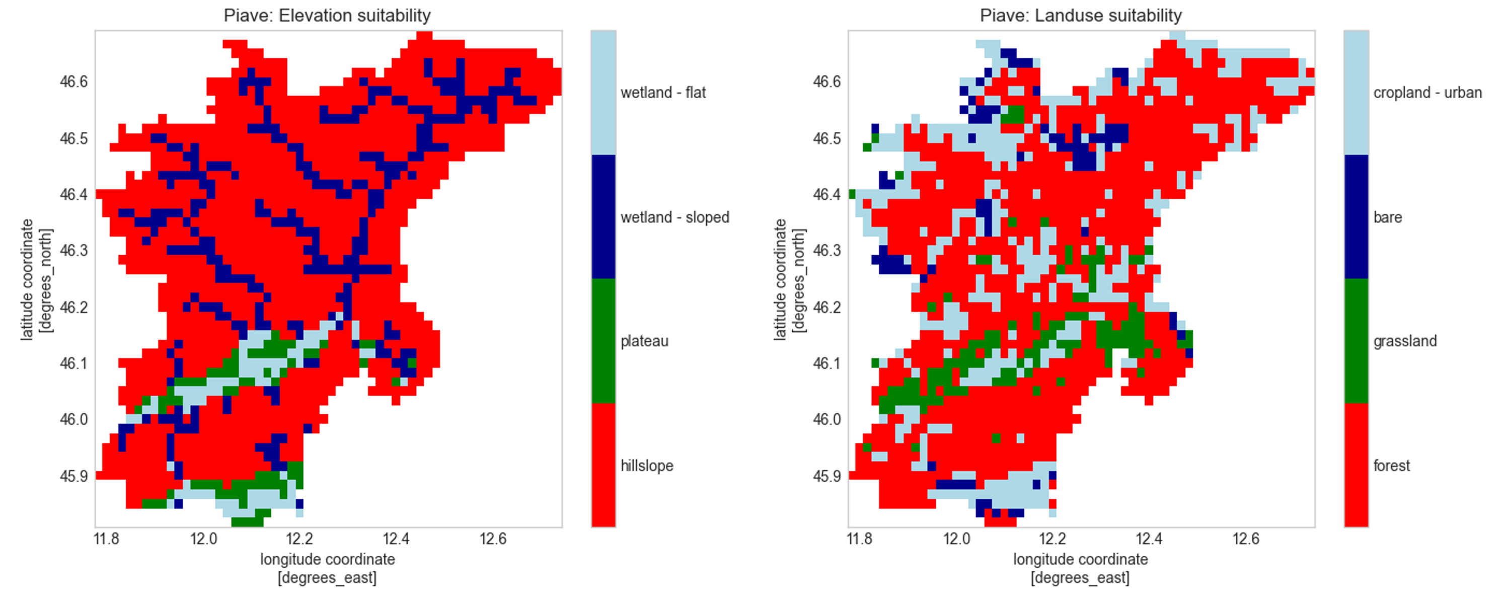
In setup_ponding_from_thresholds, the suitability map is derived by combining landuse
classes with elevation criteria. Elevation criteria including ranges in elevation, slope and
hand as used in Gharari et al. (2011)
which defines a hydrological landscape classification than can be useful for NBS:
Wetland (flat): HAND < 5.9m & slope < 0.129
Wetland (sloped): HAND < 5.9m & slope >= 0.129
Plateau: HAND >= 5.9m & slope < 0.129
Hillslope: HAND >= 5.9m & slope >= 0.129
Example usage#
Setup ponding from map#
In this example, we will set up ponding in a Wflow model based on a user-defined ponding map (vector file). We will specify a ponding level that determines the maximum depth at which water will pond on the surface.
The definition of the method and the arguments is done in a workflow file (YAML format). The workflow file can then be used to build or update a model from the command line interface. Here our input files have a simple format so we can use file paths instead of data catalog entries:
$ hydromt update wflow_sbm "./path/to/model_to_update" -o "./path/to/model_with_ponding" -i "./path/to/add_ponding.yaml" -v
The workflow YAML file (add_ponding.yaml) would look like this:
steps:
  - setup_ponding_from_map:
      pond_fn: "./path/to/pond_locations.shp" # polygons with pond locations
      pond_level: 0.1 # ponding level in m
      output_name: "ponding_level" # name of the output variable in the model staticmaps
For python, you need to first instantiate a Wflow model and then call the setup methods directly:
from hydromt_wflow import WflowSbmModel

# instantiate model
model = WflowSbmModel(
    "./path/to/model_to_update",
    mode="r+",
)

# add static inflows at GRDC gauges
model.setup_ponding_from_map(
    pond_fn="./path/to/pond_locations.shp", # polygons with pond locations
    pond_level=0.1, # ponding level in m
    output_name="ponding_level", # name of the output variable in the model staticmaps
)
Setup ponding from thresholds#
In this example, we will set up ponding in a Wflow model based on user-defined suitability criteria derived from landuse and hydrography maps. For example in the case of small ponds in forested hillslopes.
The definition of the method and the arguments is done in a workflow file (YAML format). The workflow file can then be used to build or update a model from the command line interface. Here our input files have a simple format so we can use file paths instead of data catalog entries:
$ hydromt update wflow_sbm "./path/to/model_to_update" -o "./path/to/model_with_ponding" -i "./path/to/add_ponding.yaml" -d artifact_data -v
The workflow YAML file (add_ponding.yaml) would look like this:
steps:
  - setup_ponding_from_thresholds:
      lulc_fn: "vito_2015" # landuse map
      hydrography_fn: "merit_hydro_ihu" # hydrography data
      lulc_classes: [111, 112, 113, 114, 115, 116] # closed forest classes in vito_2015
      elevtn_range: (0, 2000) # elevation range in m
      slope_range: (0.129, 0.3) # slope range in m/m
      hand_range: (5.9, 20) # hand range in m
      pond_level: 0.02 # ponding level in m
      output_name: "ponding_level_forested_hillslope" # name of the output variable in the model staticmaps
For python, you need to first instantiate a Wflow model and then call the setup methods directly:
from hydromt_wflow import WflowSbmModel

# instantiate model
model = WflowSbmModel(
    "./path/to/model_to_update",
    mode="r+",
    data_libs=["artifact_data"],
)

# add static inflows at GRDC gauges
model.setup_ponding_from_thresholds(
    lulc_fn="vito_2015", # landuse map
    hydrography_fn="merit_hydro_ihu", # hydrography data
    lulc_classes=[111, 112, 113, 114, 115, 116], # closed forest classes in vito_2015
    elevtn_range=(0, 2000), # elevation range in m
    slope_range=(0.129, 0.3), # slope range in m/m
    hand_range=(5.9, 20), # hand range in m
    pond_level=0.02, # ponding level in m
    output_name="ponding_level_forested_hillslope", # name of the output variable in the model staticmaps
)