

Setup Agroforestry#
Description#
Agroforestry is a practice that integrates trees and shrubs into agricultural landscapes.
The setup_agroforestry method is part of a set of methods to add Nature Based Solutions
(NBS) to a Hydromt Wflow model. This method allows users to integrate agroforestry
areas into the land use configuration of the model. By specifying agroforestry regions,
users can modify land use characteristics to better represent the influence of agroforestry
practices on hydrological processes.
Users can provide agroforestry zones either through a raster file or a vector file. It is also possible to convert only specific landuse types within the designated area.
Examples of raster files that can be used include:
land cover map that includes an agroforestry class
map of agroforestry areas
subcatchment map in combination with landuse type to convert (e.g. convert all agricultural areas in this subcatchment to agroforestry)
land cover map in which a whole landuse class can be converted to agroforestry (e.g. convert all agricultural areas to agroforestry)
Examples of vector files that can be used include:
polygons delineating agroforestry zones
polygons delineating subcatchments in combination with landuse type to convert (e.g. convert all agricultural areas in this subcatchment to agroforestry)
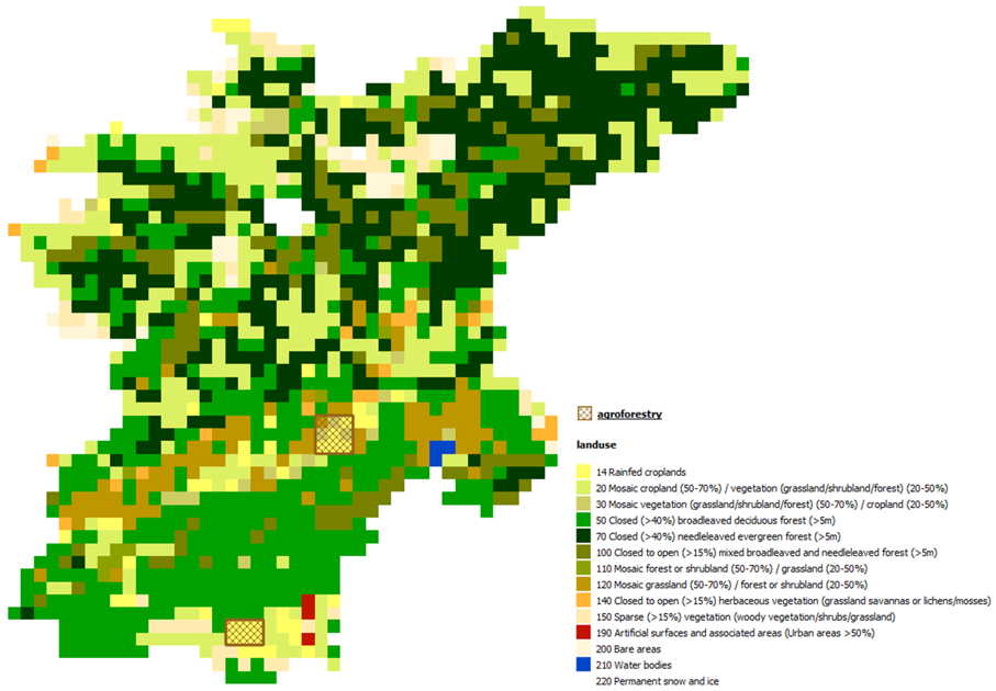
The figure below shows a wflow landuse map (from Globcover) and agroforestry zones that will be used as examples.
Note
This method works at the WFLOW MODEL RESOLUTION. It modifies the wflow landuse map by reprojecting the agroforestry raster file (mode method) or rasterizing the agroforestry polygons at the model resolution (all_touched=False). Wflow landuse parameters are then updated for the new agroforestry cells only.
Agroforestry parameters and lookup table#
Agroforestry is a NBS measure that modify the landuse and hence the landuse related
parameters in Wflow. Users have several options to define the related landuse parameters
for agroforestry. As for other setup_lulcmaps methods, users can provide a lookup table
or use the default lookup table provided with Hydromt Wflow:
agroforestry |
description |
landuse |
vegetation_kext |
land_manning_n |
soil_compacted_fraction |
vegetation_root_depth |
vegetation_leaf_storage |
vegetation_wood_storage |
land_water_fraction |
vegetation_crop_factor |
vegetation_feddes_alpha_h1 |
vegetation_feddes_h1 |
vegetation_feddes_h2 |
vegetation_feddes_h3_high |
vegetation_feddes_h3_low |
vegetation_feddes_h4 |
erosion_usle_c |
|---|---|---|---|---|---|---|---|---|---|---|---|---|---|---|---|---|---|
1 |
Agroforestry |
1 |
0.635 |
0.238 |
0 |
394.9 |
0.095 |
0.02 |
0 |
1.09 |
0 |
0 |
-100 |
-400 |
-1000 |
-16000 |
0.234 |
Or users can provide a complete landuse lookup table and define their own mix of landuse classes and fractions to represent agroforestry areas, for example 90% cropland and 10% shrubs. For example, the values in the default agroforestry lookup table above were derived use the esa_worldcover_mapping_default lookup table with a mix of 75% cropland (class 40), 15% shrubs (class 20) and 10% trees (class 10).
Example usage#
Here are three examples of how to use the setup_agroforestry method in a Hydromt Wflow model:
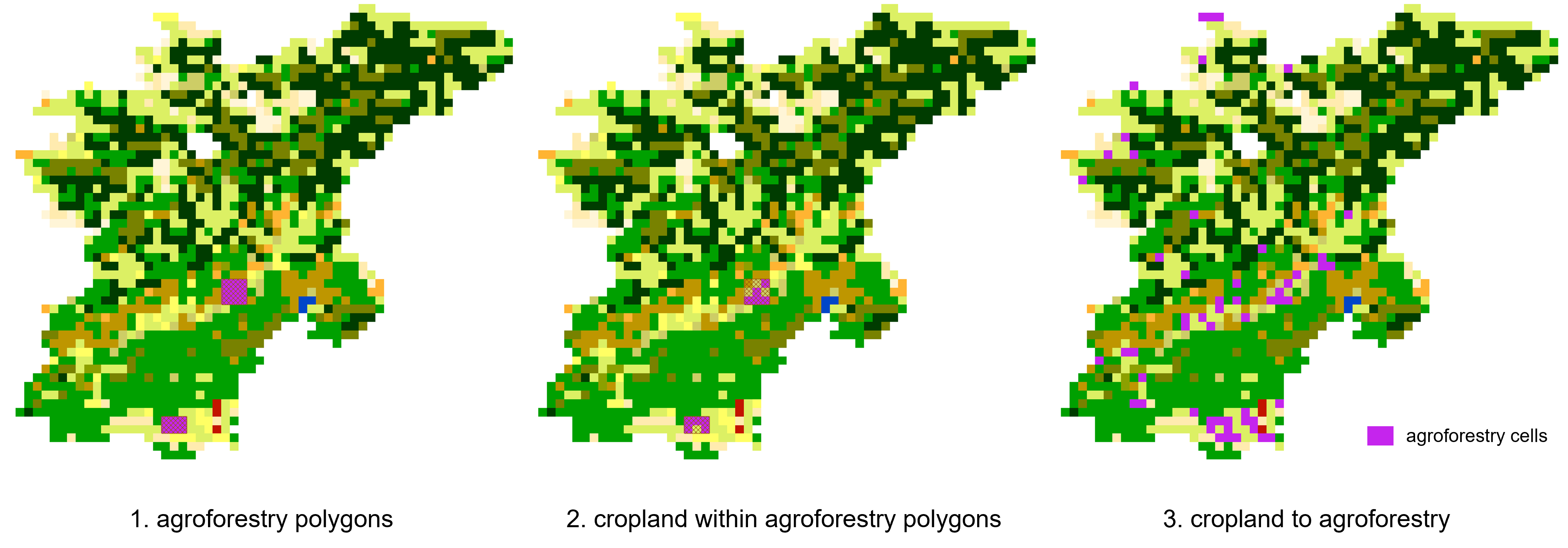
Using a vector file to define agroforestry areas and a mix of 90% cropland and 10% shrubs of the esa_worldcover_mapping_default lookup table.
Same as above, but only cropland cells (class 14 in globcover) will be converted to agroforestry areas within the polygons.
Converting all agricultural areas in the catchment above (class 14 in globcover) to agroforestry areas and using the default agroforestry lookup table.
The definition of the method and the arguments is done in a workflow file (YAML format).
The workflow file can then be used to build or update a model from the command line interface.
For example, using the pre-defined artifact_data catalog:
$ hydromt update wflow_sbm "./path/to/model_to_update" -o "./path/to/model_with_agroforestry" -d "artifact_data" -i "./path/to/add_agroforestry.yaml" -v
For our first example, the workflow YAML file (add_agroforestry.yaml) would look like this:
steps:
  - setup_agroforestry:
      agroforestry_fn: "agroforestry areas" # data catalog entry
      output_agroforestry_class: 15 # new landuse class for agroforestry areas
      lulc_mapping_fn: "esa_worldcover_mapping_default" # esa_worldcover lookup table
      lulc_mix_classes: [40, 20] # cropland, shrubs classes in esa_worldcover
      lulc_mix_fractions: [0.9, 0.1] # 90% cropland, 10% shrubs
      output_names_suffix: "agroforestry" # suffix for the new staticmap names
For our second example, the workflow YAML file (add_agroforestry.yaml) would look like this:
steps:
  - setup_agroforestry:
      agroforestry_fn: "agroforestry areas" # data catalog entry
      output_agroforestry_class: 15 # new landuse class for agroforestry areas
      landuse_class_filter: [14] # only convert cropland cells in agroforestry_fn
      lulc_mapping_fn: "esa_worldcover_mapping_default" # esa_worldcover lookup table
      lulc_mix_classes: [40, 20] # cropland, shrubs classes in esa_worldcover
      lulc_mix_fractions: [0.9, 0.1] # 90% cropland, 10% shrubs
      output_names_suffix: "agroforestry" # suffix for the new staticmap names
For our third example, the workflow YAML file (add_agroforestry.yaml) would look like this:
steps:
  - setup_agroforestry:
      agroforestry_fn: "globcover" # globcover landuse raster
      agroforestry_class: 14 # globcover agricultural class
      output_agroforestry_class: 15 # new landuse class for agroforestry areas
      agroforestry_mapping_fn: "agroforestry_mapping_default" # default agroforestry lookup table
For python, you need to first instantiate a Wflow model and then call the setup methods directly:
from hydromt_wflow import WflowSbmModel

model = WflowSbmModel(
  root="path/to/model_to_update",
  mode="r+",
  data_libs=["artifact_data"]
)
For our first example, the python code would look like this:
model.setup_agroforestry(
    agroforestry_fn="agroforestry areas", # data catalog entry
    output_agroforestry_class=15, # new landuse class for agroforestry areas
    lulc_mapping_fn="esa_worldcover_mapping_default", # esa_worldcover lookup table
    lulc_mix_classes=[40, 20], # cropland, shrubs classes in esa_worldcover
    lulc_mix_fractions=[0.9, 0.1], # 90% cropland, 10% shrubs
    output_names_suffix="agroforestry" # suffix for the new staticmap names
)
For our second example, the python code would look like this:
model.setup_agroforestry(
    agroforestry_fn="agroforestry areas", # data catalog entry
    output_agroforestry_class=15, # new landuse class for agroforestry areas
    landuse_class_filter=[14] # only convert cropland cells in agroforestry_fn
    lulc_mapping_fn="esa_worldcover_mapping_default", # esa_worldcover lookup table
    lulc_mix_classes=[40, 20], # cropland, shrubs classes in esa_worldcover
    lulc_mix_fractions=[0.9, 0.1], # 90% cropland, 10% shrubs
    output_names_suffix="agroforestry" # suffix for the new staticmap names
)
For our third example, the python code would look like this:
model.setup_agroforestry(
    agroforestry_fn="globcover", # globcover landuse raster
    agroforestry_class=14, # globcover agricultural class
    output_agroforestry_class=15, # new landuse class for agroforestry areas
    agroforestry_mapping_fn="agroforestry_mapping_default" # default agroforestry lookup table
)
Lastly, you need to write the updated model:
model.write()
The output landuse map from the different examples are (agroforestry zones in purple):