Introduction to HydroMT#
Why HydroMT?#
HydroMT (Hydro Model Tools) is an open-source Python package that facilitates the process of building and analyzing spatial geoscientific models with a focus on water system models. It does so by automating the workflow to go from raw data to a complete model instance which is ready to run and to analyze model results once the simulation has finished. As such it is an interface between user, data and hydro models. Furthermore it does so in a fast, flexible, scalable, modular and reproducible manner.
This process, before HydroMT is pictured below:
A sequence of a typical pre-analysis workflow, before HydroMT was invented#
In contrast to the image above, the same workflow using HydroMT is depicted in the next image:
A sequence describing how the pre-analysis goes using HydroMT#
With HydroMT, users can focus on the science and analysis of their models, rather than the tedious and error-prone task of preparing input data and model files. HydroMT provides a standardized and efficient way to build, update and analyze hydrological models, making it easier for researchers and practitioners to work with complex water system models.
With its data-centered approach, users can with HydroMT:
Rapidly build and update model instances anywhere in the world
Prepare small to large-scale applications
Use a wide range of input data formats and sources and combinations of global and local datasets thanks to the flexible data catalog and harmonization capabilities
Focus on collecting and improving relevant input data rather than correcting model files
Leverage pre-defined methods and workflows for common hydrological modeling tasks
Reuse workflows and methods between different model software through a plugin architecture
How to use HydroMT ?#
HydroMT and plugins#
More often than not, we use HydroMT together with a plugin to work with specific model software. HydroMT core then provides the command line and Python interface, data handling via the data catalog (and adapters) and generic GIS methods.
The plugin provides model-specific GIS methods and allows to read and write model data in the model’s native format.
Common usage#
The most common usage of HydroMT is to build a model from scratch and to update and visualize an existing model. Here, a high-level example of how to build a model using HydroMT is provided. Building a model from scratch with HydroMT involves the following generic steps:
Define the input data in a yaml data catalog file or selects available datasets from a pre-defined data catalog.
Define the model region which describes the area of interest. The model region can be based on a simple bounding box or geometry, but also a (sub)(inter)basin that is delineated on-the-fly based on available hydrography data.
Configure the model setup in an yaml configuration file. A HydroMT yaml configuration file represents a reproducible recipe to build a model by listing (in order of execution) the model methods and their arguments. These methods and their arguments are described in the documentation.
Run the HydroMT build method from either command line (as shown in the figure) or Python.
HydroMT interface#
HydroMT provides both a command line interface (CLI) and a Python application programming interface (API) to build and update models. Here are examples of how to use both interfaces to build a model from a configuration file.
$ hydromt build wflow_sbm "./path/to/wflow_model" -d "./path/to/data_catalog.yml" -i "./path/to/build_options.yaml" -v
from hydromt import log
from hydromt_wflow import WflowSbmModel
from hydromt.readers import read_workflow_yaml

# Configure logging
log.initialize_logging()

# Instantiate model
model = WflowSbmModel(
    root="./path/to/wflow_model",
    data_catalog=["./path/to/data_catalog.yml"],
)
# Read build options from yaml
_, _, build_options = read_workflow_yaml(
    "./path/to/build_options.yaml"
)
# Build model
model.build(steps=build_options)
If you use the command line interface, only a few high-level commands are available to build and update models or export data from the data catalog. If you use the Python API, you can also access the underlying methods of HydroMT to read data from a catalog, perform GIS operations or write your own plugin.
How does HydroMT work?#
The main use of HydroMT is to build or update a model instance from raw data. This includes reading and harmonizing the raw input data via the Data Catalog, and transforming the data through a series of methods and (GIS) processes to the model specific format and requirements.
Users can interact with HydroMT through a Command Line Interface (CLI) or directly through the Python API. They tell HydroMT information on the data to use in one or several data catalog files, and define the steps to go from raw data to a model instance in a model build configuration (or workflow) file (for example which DEM data to use, what is the spatial resolution, etc.). HydroMT then executes the defined steps to build or update the model instance.
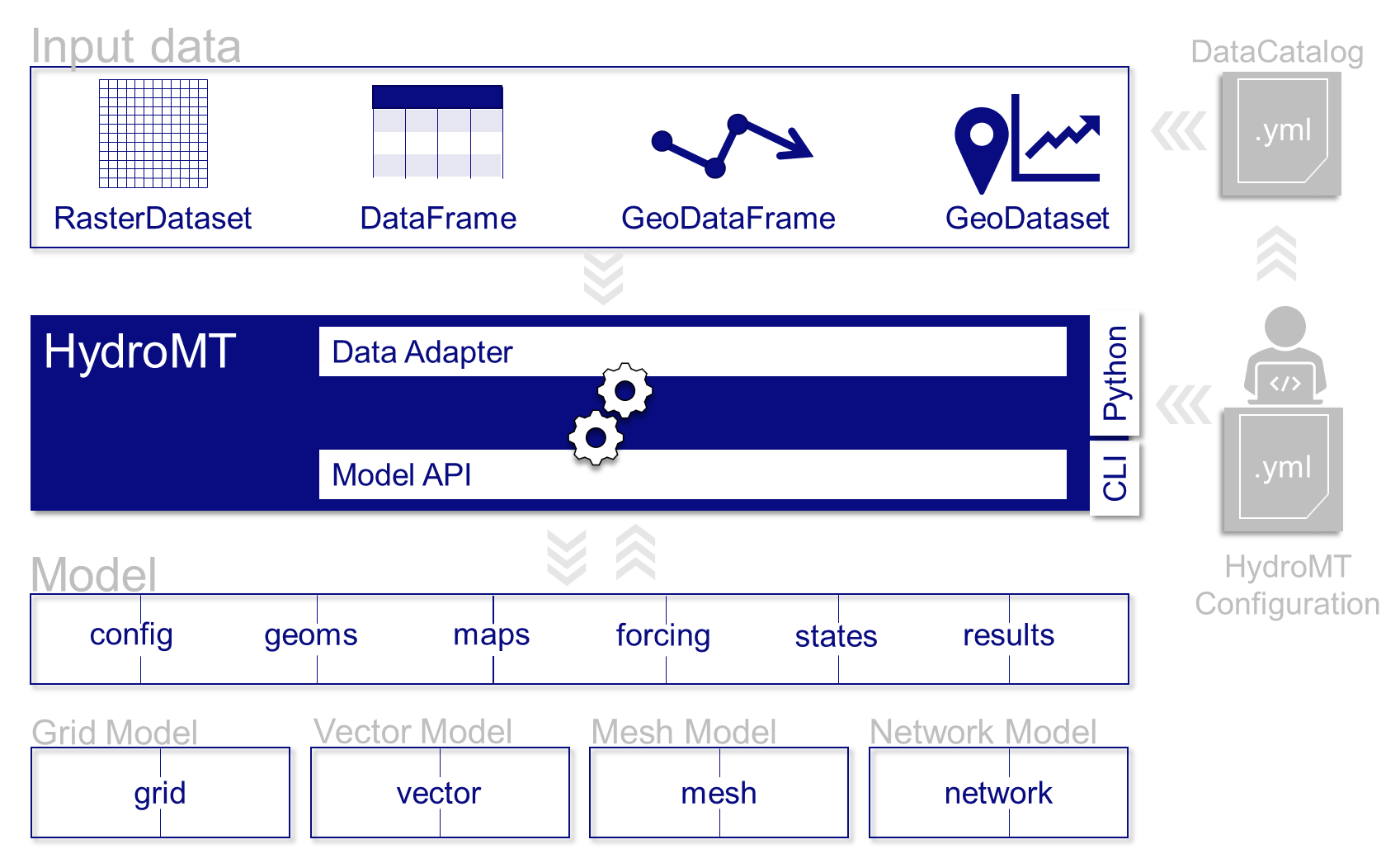
A diagram showing an overview of the architecture of HydroMT.#
More concretely HydroMT is organized in the following way:
Input Data#
HydroMT is data-agnostic through the Data Catalog, which allows to read a wide range of data formats and unify
the input data (e.g., on-the-fly renaming and unit conversion). Datasets are listed and passed to HydroMT
in a user defined data catalog yaml file. HydroMT also provides several
pre-defined data catalogs with mostly global datasets that can be used as is,
although not all datasets in these catalogs are openly accessible.
Currently, five different types of input data are supported by HydroMT and represented by a specific Python data object:
gridded datasets such as DEMs or gridded spatially distributed rainfall datasets (represented by RasterDataset objects, a raster-specific extension of Xarray Datasets)
tables or tabular data, that can be used to, for example, convert land use classes to model parameters (represented by Pandas DataFrame objects)
vector datasets such as administrative units or river center lines (represented by Geopandas GeoDataFrame objects)
time series with associated geo-locations such as observations of discharge (represented by GeoDataset objects, a geo-specific extension of Xarray Datasets)
non-spatial N-dimension data (represented by Xarray Dataset objects).
Under the hood, when HydroMT reads data from the catalog, it uses the uri provided to locate
the data, a Driver to read the data from file using the appropriate python function for the
specific format of the data (e.g. gridded datasets are read with rasterio for GeoTiff files or with xarray
for NetCDF and zarr files), and a Data Adapter to read only the correct variables, slice the data
for the required spatial region and time, and harmonize the data to HydroMT standards (e.g. renaming
variables or converting units).
Models#
HydroMT defines any model instance through the model-agnostic Model class that is composed
of several Model Components. These components typically represent a specific type of model data
or file such as:
a configuration component, for model settings, output options, etc. (usually represented as a dictionary)
a static spatial component, for example static gridded data or mesh data depending on the model schematization (usually represented with a xarray object)
a forcing component, for time-varying inputs such as rainfall or temperature (usually represented with a xarray object)
etc.
The available model components and the underlying python object containing the data will
vary depending on the model software being used. Model instances can be built from scratch,
and existing models can be updated step-by-step based on a pipeline of methods
defined in a model build workflow .yaml file.
While HydroMT provides several general model components that can readily be used, each model software is unique in its own way either because it has specific data requirements or because its input file formats differ (netcdf or ascii or binary…). So HydroMT can easily be tailored to specific model software through a plugin infrastructure. These plugins have the same interface, but with model-specific components, file readers, writers and workflows. In practice, you will most probably use HydroMT together with a specific plugin for your model software of choice that HydroMT core on its own.
Methods and (GIS) processes#
Most of the heavy work in HydroMT is done by Methods and (GIS) processes,
indicated by the gear wheels in the architecture diagram above. Methods provide the low-level functionality
such as rasterization, reprojection, or zonal statistics. Processes combine several methods to
transform the raw input data to a model layer or parameters. Examples of processes include the
delineation of hydrological basins (watersheds), conversion of landuse-landcover data to model
parameter maps, and calculation of model skill statistics.
The list of processes to use as well as their order and options are defined in a
model build workflow .yaml file. HydroMT comes with a set of
pre-defined methods and processes that can be used as is, but plugins will typically
extend this list with model-specific methods and processes.
For advanced users or developers, HydroMT exposes all methods and processes through its Python API. Feel free to check the API reference for all available functions.
Command Line Interface (CLI) and python interface (API)#
Finally users can interact with HydroMT through the following interfaces:
Command Line Interface (CLI): the CLI is a high-level interface to HydroMT. It is used to run HydroMT commands such as build, update
Python Interface: while most common functionalities can be called through the CLI, the Python interface offers more flexibility for advanced users. It allows you to e.g. interact directly with a model component Model API and apply the many methods and processes available.
Check the next page of this Overview section for a quickstart on how to use HydroMT through the CLI and the Python API.
Summary#
To summarize, the functionality of HydroMT can be broken down into four components, which are around input data, model instances, methods and workflows. Users can interact with HydroMT through a high-level command line interface (CLI) to build model instances from scratch, update existing model instances or analyze model results. Furthermore, a Python interface is available that exposes all functionality for experienced users.
This page is an overview of the main architecture and concepts of HydroMT. If you would like to know more, please visit the detailed architecture in the developer guide.