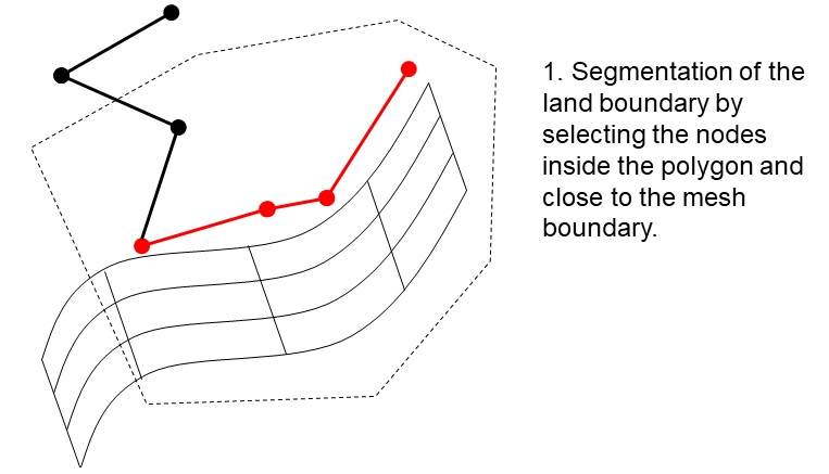
A class describing land boundaries. These are used to visualise the land-water interface. More...
#include <LandBoundaries.hpp>
Public Types | |
| enum class | ProjectToLandBoundaryOption { DoNotProjectToLandBoundary = 0 , ToOriginalNetBoundary = 1 , OuterMeshBoundaryToLandBoundary = 2 , InnerAndOuterMeshBoundaryToLandBoundary = 3 , WholeMesh = 4 } |
| Enumerator describing the options how to project to the land boundary. | |
Public Member Functions | |
| LandBoundaries ()=default | |
| Default constructor. | |
| LandBoundaries (const std::vector< Point > &landBoundary, Mesh2D &mesh) | |
| Constructor. | |
| LandBoundaries (const std::vector< Point > &landBoundary, Mesh2D &mesh, const Polygons &polygons) | |
| Default constructor. | |
| void | Administrate () |
| The portion of the boundary segments close enough to the mesh boundary are flagged (admin_landboundary_segments) | |
| void | FindNearestMeshBoundary (ProjectToLandBoundaryOption projectToLandBoundaryOption) |
| Find the mesh boundary line closest to the land boundary (find_nearest_meshline). | |
| std::unique_ptr< UndoAction > | SnapMeshToLandBoundaries () const |
| Snap the mesh nodes to land boundaries (snap_to_landboundary) | |
| auto | GetNumNodes () const |
| Gets the number of land boundary nodes. | |
Public Attributes | |
| std::vector< UInt > | m_meshNodesLandBoundarySegments |
| Mesh nodes to land boundary mapping (lanseg_map) | |
Detailed Description
A class describing land boundaries. These are used to visualise the land-water interface.
The main responsibility of this class is to store the land boundary polygons, categorize them based on their proximity to a mesh and provide the functionality to assign each mesh node to the appropriate land boundary polyline.
Constructor & Destructor Documentation
◆ LandBoundaries() [1/2]
| meshkernel::LandBoundaries::LandBoundaries | ( | const std::vector< Point > & | landBoundary, |
| Mesh2D & | mesh | ||
| ) |
Constructor.
- Parameters
-
[in] landBoundary A vector of points defining the land boundary. [in] mesh The current 2d mesh.
◆ LandBoundaries() [2/2]
| meshkernel::LandBoundaries::LandBoundaries | ( | const std::vector< Point > & | landBoundary, |
| Mesh2D & | mesh, | ||
| const Polygons & | polygons | ||
| ) |
Default constructor.
- Parameters
-
[in] landBoundary A vector of points defining the land boundary. [in] mesh The current 2d mesh. [in] polygons A polygon for selecting part of the land boundaries.
Member Function Documentation
◆ Administrate()
| void meshkernel::LandBoundaries::Administrate | ( | ) |
The portion of the boundary segments close enough to the mesh boundary are flagged (admin_landboundary_segments)
This method uses a Point vector member variable and identifies the start-end points of each land boundary polyline with the requirement that all polyline nodes are close enough to the mesh boundary and are inside the polygon.

◆ FindNearestMeshBoundary()
| void meshkernel::LandBoundaries::FindNearestMeshBoundary | ( | ProjectToLandBoundaryOption | projectToLandBoundaryOption | ) |
Find the mesh boundary line closest to the land boundary (find_nearest_meshline).
- Parameters
-
[in] projectToLandBoundaryOption The option describing the projection to the land boundary.
◆ GetNumNodes()
|
inline |
Gets the number of land boundary nodes.
- Returns
- The number of land boundary nodes.
The documentation for this class was generated from the following file:
- /home/runner/work/MeshKernel/MeshKernel/libs/MeshKernel/include/MeshKernel/LandBoundaries.hpp