Defining a model region#
To setup a model for a specific region, you can use several geospatial or hydrographic region definitions which are explained in this chapter.
The syntax is interpreted using the parse_region() method.
For hydrographic regions see also the delineate basins example and get_basin_geometry() method.
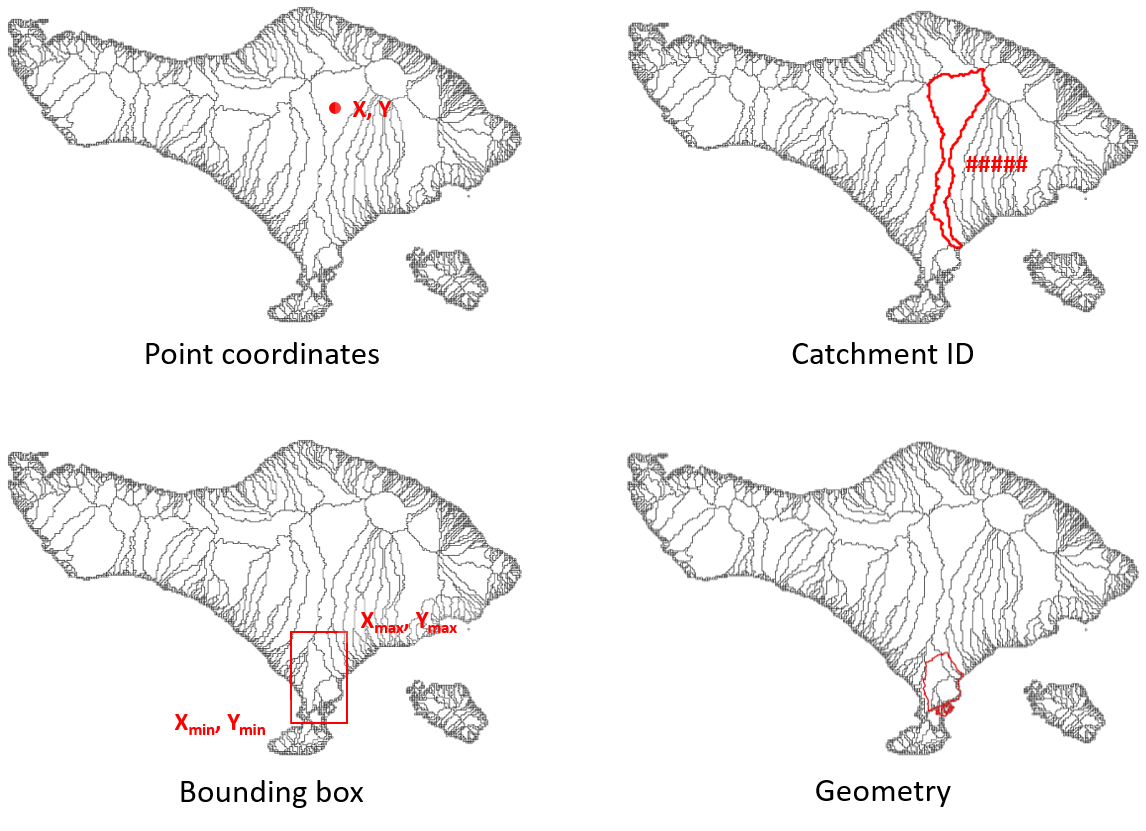
Examples of region types supported in HydroMT#
Note
All x and y coordinates in the point and bbox are in the EPSG:4326 (WGS84) coordinate reference system. For hydrographic regions, the coordinates should be in the same CRS as the hydrography dataset used for delineation. Note that this can depend per HydroMT plugin so please check the documentation of the plugin you are using.
Geospatial region#
Bounding box (bbox):
{'bbox': [xmin, ymin, xmax, ymax]}Geometry file (geom):
{'geom': '/path/to/geometry_file'}Based on another model:
{'<model_name>': '/path/to/model_root'}Based on a raster file:
{'grid': '/path/to/raster_file'}Based on a mesh file:
{'mesh': '/path/to/mesh_file'}
Hydrographic region#
The following hydrographic regions are supported:
basin
subbasin
interbasin
Basin: is defined by the entire area which drains to the sea or an inland depression. To delineate the basin(s) touching a region or point location, users can supply the following:
One point location:
{'basin': [x, y]}More point locations:
{'basin': [[x1, x2, ..], [y1, y2, ..]]}Bounding box:
{'basin': [xmin, ymin, xmax, ymax]}Geometry file:
{'basin': '/path/to/geometry_file'}Single unique basin ID:
{'basin': [ID1]}Several unique basin ID:
{'basin': [ID1, ID2, ..]}To filter basins within a bounding box or geometry file, variable-threshold pairs to define streams can be used, e.g.:
'uparea':30to filter based on streams with a minimum drainage area of 30 km2 or'strord':8to filter basins based on streams with a minimal stream order of 8. The variables should be available in the dataset on which the delineation is based, e.g. Hydro MERIT.
{'basin': [xmin, ymin, xmax, ymax], '<variable>': threshold}To only select basins with their outlet location use
'outlets': truein combination with a bounding box or geometry file
{'basin': [xmin, ymin, xmax, ymax], 'outlets': true}
Subbasin: is defined by the area that drains into an outlet, stream or region. Users can supply the following:
One point location:
{'subbasin': [x, y]}More point locations:
{'subbasin': [[x1, x2, ..], [y1, y2, ..]]}Bounding box:
{'subbasin': [xmin, ymin, xmax, ymax]}Geometry file:
{'subbasin': '/path/to/geometry_file'}Where x, y coordinates are those of the outlet(s) of the sub-basin to derive. To speed up the delineation process users can supply an estimated initial bounding box in combination with all the options mentioned above. A warning will be raised if the bounding box does not contain all upstream area.
{'subbasin': [x, y], 'bounds': [xmin, ymin, xmax, ymax]}The sub-basins can further be refined based on one (or more) variable-threshold pair(s) to define streams, as described above for basins. If used in combination with point outlet locations, these are snapped to the nearest stream which meets the threshold criteria.
{'subbasin': [x, y], '<variable>': threshold}
Interbasin: is defined by the area that drains into an outlet or stream and bounded by a region and therefore does not necessarily include all upstream area. Users should supply a bounding region in combination with stream and/or outlet arguments. The bounding region is defined by a bounding box or a geometry file; streams by a (or more) variable-threshold pair(s) and outlet by point location coordinates. Similar to sub-basins, point locations are snapped to nearest downstream stream if combined with stream arguments.
{'interbasin': [xmin, ymin, xmax, ymax], '<variable>': threshold}
{'interbasin': /path/to/geometry_file, '<variable>': threshold}
{'interbasin': [xmin, ymin, xmax, ymax], '<variable>': threshold, 'xy': [x, y]}To only select interbasins based on the outlet location of the entire basins use
'outlets': true
{'interbasin': [xmin, ymin, xmax, ymax], 'outlets': true}