D-Stability
D-Stability model
The D-GEO Suite Stability (D-Stability) model definition. |
Tutorial
You can find the D-Stability tutorial here: Tutorials D-Stability
A tutorial for making a fragility curve using D-Stability can be found here: Creating a Fragility Curve
Geometry
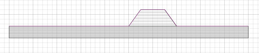
Add layer
For the geometry it is import to set the geometry points in the correct order. I.e. per polygon, set the points in clockwise or anticlockwise order. Furthermore it is import to add all points which are part or touch a certain polygon. This procedure is automatically done when the user creates a geometry via the user interface. However when the user wants to create a geometry via Geolib, it is important to specify all points for each layer. An example is illustrated below.
The following valid code will produce a correct geometry, note that the clay layer is a rectangular layer, but still requires 6 geometry points. This is because the dike layer touches the clay layer at two points. If the clay layer is only generated the 4 corner points, a valid geometry is generated, however unexpected results can occur.
import geolib
from geolib.geometry import Point
from pathlib import Path

ds = geolib.DStabilityModel()

clay_points = [Point(x=-50, z=-10),
               Point(x=-50, z=-5),
               Point(x=0, z=-5),
               Point(x=20, z=-5),
               Point(x=50, z=-5),
               Point(x=50, z=-10)]

dike_points = [Point(x=5, z=2),
               Point(x=15, z=2),
               Point(x=20, z=-5),
               Point(x=0, z=-5)]

soil_clay= geolib.soils.Soil()
soil_dike = geolib.soils.Soil()
soil_clay.code = 'clay'
soil_dike.code = 'dike'

ds.add_soil(soil_clay)
ds.add_soil(soil_dike)

ds.add_layer(clay_points, soil_clay.code)
ds.add_layer(dike_points, soil_dike.code)

ds.filename = Path('geometry_example.stix')
ds.serialize(ds.filename)